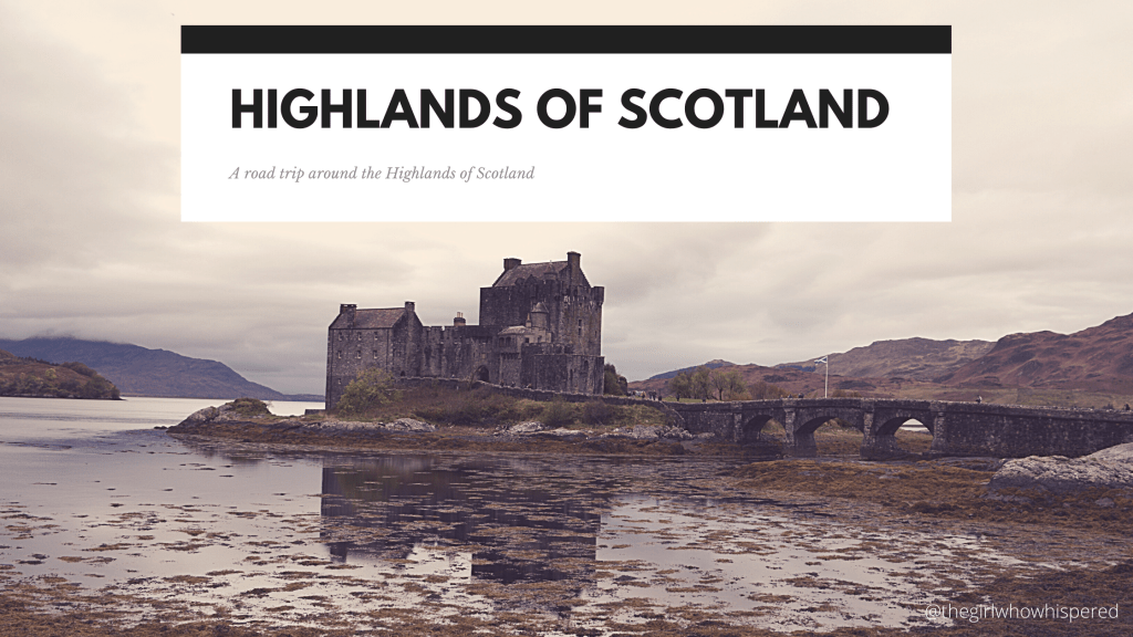
The Highlands of Scotland Road Trip

Hello my little demons,

As most of you know, I moved to the Highlands of Scotland at the beginning of 2020 and was super excited to explore and share my travels with you guys. But then Covid-19 hit and I was pretty much confined to a single room with a very lovely family for about eight months and wasn’t able to get very far (I wrote two blog posts about this, I’ll leave the links at the end). The whole country; United Kingdom, went into lockdown in March 2020 and it eased for a few months before the majority of the country (at least England) going into lockdown again (and now we’re in another nationwide lockdown – including Scotland!). During those few months lockdown lifted, a friend of mine booked some time off work and decided to drive all the way up to Scotland to see me, and of course, see the Highlands of Scotland!

I firstly want to say, keep safe and don’t do any unnecessary trips, especially if you are in lockdown! If we all do our part, we can get out of this pandemic quicker.

On that note, I also want to say that this trip was done pre-lockdown. We also made a lot of precautions, including having hand sanitizer in the car, which we used very frequently, wore masks when going inside public buildings and kept 2 meters apart from other people. Luckily, the Highlands wasn’t very busy and the majority of it is wild and people-free. My friend also booked a hotel in Inverness for the whole week, we didn’t book any other hotels in the Highlands so as to avoid spreading the virus, so we explored the Highlands one day at time.

Now, I hope you enjoy the rest of this blog!

Day One – Packing and checking into the Hotel

The first day wasn’t that eventful, as my friend was driving over 500 miles from South West England to the Highlands. But, as I had finally found my own place, moving out of the single bedroom in a lovely family’s house into my own very first flat in the Highlands, I was packing my things – not that I had much to pack – and cleaning the room before he arrived.

As I mentioned in the little ‘disclaimer’ in the beginning of the blog post, my friend booked a hotel in Inverness city centre for the week, and had booked a twin room just in case I decided to stay so we could wake up early and set off straight away on adventures. I decided it would be best to just stay there, so I could clean the room before the adventure starts. Not having to go back to the house, clean, move my stuff into my flat half way through the adventure – no time was wasted!

When my mate did arrive, we bundled everything into the car, and because I am a massive motor-head, I have to mention he has a Mark 2 Ford Focus ST, which has been, err… ‘slightly’ modified. I won’t post any photos of it, as it is a little too easily distinguished. Once packed, we just went straight to the hotel, ordered a pizza, bought some beers/cider and chilled in front of the TV.

Day Two – The long way to the Isle of Skye

On day two, this is when the fun starts. We got up with the sole intention of driving to Bealach na Bà or also known as Applecross Path. The actual town of Applecross, at the end of the path, wasn’t the main attraction here, but the road to it, and it’s absolutely stunning!

But, of course, Applecross is a lovely little fishing village too, which deserves a mention. But as they say, it’s the journey, not the destination.

After a quick stop, having cold pizza left over from last night, a quick loo break, we then headed south to a little village called Plockton. I only really wanted to go because I thought the name was funny (and yes, I kept calling it Plonkton because I’m a child), and I quickly found it on a website of places to visit in the area… but I had no idea it was this pretty!

After a small walk about, and a stop in the local gift shop to get my obligatory postcards (it’s one of the things I collect), we got back into the car and decided Eilean Donan Castle wasn’t that far away and deserves at least a quick stop.

Now, this castle I have heard about and drove past at least twice before, once on the way to the Isle of Skye back in the summer of 2018 and back again only a month later – I had worked on the Isle of Skye for a few weeks, not being able to hack the job so ended up returning to my parents – I remember driving past the Castle and wishing I could stop to see it. The below photo shows you why.

Unfortunatley, it was a little busier than I had expected. We did visit in a Scottish school holiday, so there were a few people about, and it’s a popular tourist destination – well, it is on the way to the Isle of Skye!

Which brings me onto the end of the day, a quick trip over to the Isle of Skye!

Of course, there isn’t much in terms of photos, as we didn’t spend long there. We did, however, drive most of the Island, but the majority of it we were searching for a toilet! Word of warning, if you’re planning on touring about – make sure you empty your bladder as soon as you can! You don’t know when the next toilet will be!

By the time we did a loop and got back to Portree, the light started to fade not long after, so we stopped for a few minutes, enjoying the view of the harbor before heading back to the mainland.

Of course, we stopped by Eilean Donan Castle to see it lit up at night. We did, apparently, drive past Loch Ness on the way back, I did see it a little, but it was too dark to get any decent photos of it – plus, that was planned for another day!

Day Three – Oil Rigs, Lighthouses, Castles and Beaches

Day three and this one started off a little different. My mate told me about this area which holds a graveyard of oil rigs in Invergordon. Okay, so it’s not technically a graveyard, as they’re there to either be repaired or taken apart. But, in a weird way, I was impressed. Not your usual tourist stop.

This was our main point of call when we set off that morning. But as we knew it wouldn’t take all day to look at some oil rigs, we also had a bit of a wander about. We headed north after finding there was a lighthouse not that far away called Tarbat Ness Lighthouse.

We also had to stop off at this strange church and graveyard that we drove past to get to it – and had to drive past on the way back (on Google Maps it’s labeled as Tarbat Discovery Centre).

We then headed up the coast a bit more, to a castle that I had come across while researching places to visit; Dunrobin Castle. And I am glad we decided to stop, because it is absolutely beautiful! I actually had a couple of my photos printed and waiting to be framed!

Lastly, for the day, we also stopped at a beach a little further up as the sun was slowly setting, called Brora. Here we walked along the sand just soaking in the coastline for a bit, before getting a little cold – and worrying about getting stuck in the dark – and decided to head back to Inverness for an early night – we had a long day ahead the next day!

Day four – driving (part) of the NC500

Day four was the big one, the one we both were looking forward to doing: the NC500, or North Coast 500, if you didn’t know what that is, it Scotland’s “Route 66”. As the official website (northcoast500.com) says:

“Embark on one of the world’s most iconic coastal touring routes,
and discover the breath-taking beauty of the North Highlands;
a place where you’ll find white sand beaches, rugged mountains,
hidden gems and a wealth of unforgettable experiences.”

The route pretty much does the whole rim of the Highlands (see image below), although we didn’t do ALL of it – but we did most, in just one day. Most people go anti-clockwise, going north up to Wick first then round to the West coast, but as we were trying to do it all in one day (I don’t recommend this, but it goes to show that it is doable if you want to see if and are strapped for time) we went straight across to Ullapool to do the West coast in the daylight getting to John O’ Groats as the sun was just setting.

But, of course, we saw a lot of other stretches on other days, such as Applewood which you can see on South West of the map and Dunrobin Castle is close to Glospie on the A9 north of Inverness.

Image Source: https://en.wikipedia.org/wiki/North_Coast_500

We began our day being woken up pretty early (I think it was about 4 in the morning), because the fire alarm had gone off. We intended to get up early, hoping to hit our first stop just as the sun was rising but 4 in the morning was a little too early.

So, we had to rush outside in our PJs, the dark, damp, cold to wait for the fire engines to come and be allowed back into the building. I can’t remember what the issue was, but it was a false alarm, but luckily I managed to get back to sleep for a few more hours, finally waking up at 6ish.

We already had bought a few things from the shops the previous day, so we didn’t even stop for breakfast. We set off nearly right away (give me time to wake up and put makeup on!) and our first stop was Corrieshalloch Gorge.

Looking at the pictures of this bridge, and it looks harmless, but you get on it and wow, does it make your legs go to jelly! The bridge didn’t just wobble up and down like a typical suspension bridge would, but it also wobbled side to side! My mate even refused to get on it!

We only spent about 15-20 minutes there (feeling as if buying a parking ticket was pointless), but it is possible to walk around it a little, which I wish I did, but we were on a tight schedule to get to the top before sunset!

So, onwards to Ullapool.

I’m sure Ullapool has a lot more going for it than what we saw, but we only really stopped at Tesco’s to stock up on food/snacks, sit along the harbor front to have brunch (it wasn’t quite breakfast, but wasn’t quite lunch) and then set off again on our day trip.

We did stop quickly at Scourie Jetty, which we were extremely impressed to see the water was so clear! But, had to move on as yours truly needed to find a toilet again!

Our next stop was a little bit more north to Balnakeil Beach (Close to Durness on the map above). The one thing that I was hoping to see… and this might sound odd, but sod it… I honestly thought I might see some cows on the beach! I remember looking it up thinking it looks absolutely beautiful and then saw photos of these lovely black cows walking on the sand. Needless to say, I didn’t see cows on the beach, but I am glad I got to see such a beautiful beach… even if it was a little cold!

Before I tell you the next stop, I just want to throw in some photos of the view we had along the way, both between Ullapool and Balnakeil Beach but also after it.

Next was Smoo Cave (yes, you read that right!) and this was one I was really looking forward to! (Also close to Durness). Unfortunately, we weren’t the only ones who had the great idea to see it, as there were a few other people about – probably not as many as if it was peak season and no pandemic, but there was at least one that was a little loud, but I just ignored that one little annoyance and was impressed nonetheless. Although, I had hoped the cave went a little deeper, but that’s just me and my (weird) interest in caves!

The cave entrance is 50ft high, and is apparently the largest sea cave entrance in Britain (source link). One story I read is that it was believed to be the residence of the Devil, which I found pretty fascinating, but couldn’t find much about it online. If you’d like to read more about Smoo Cave, here are a few interesting and insightful links I did find: https://www.undiscoveredscotland.co.uk/durness/smoocave/index.html
https://en.wikipedia.org/wiki/Smoo_Cave

The next stop was an unplanned stop, but as we were approaching it we saw how beautiful it was and had to stop – plus, the sun came out for us for a little bit which made it even more beautiful – and actually warmed up a little.

This is Ceannabeinne Beach…

And yes, if it wasn’t cold and it was open, I would totally have done that zip wire!

Our next stop was Melvich Beach, this one was at the request of my mate, and again, you can see why the west coast of Scotland is renown for it’s beaches! Unfortunately, as soon as we got there, it started to cloud over and most of my pictures are dark, and doesn’t do it any justice compared to the previous ones.

After Melvich Beach, the next stop was the most northern part of mainland Britain – No, not John O’ Groats! Dunnet Head! John O’ Groats isn’t the most northern part of Britain, it’s actually the end of the longest distance between two inhabited British points (Land’s End, Cornwall being the most southernly).

Dunnet Head is in fact the most northerly point of Scotland and Britain. Actually, if you want to be exact, Dunnet Head is the area, the tip is ‘known’ as Easter Head (or at least Wikipedia says it is, so it might be true?)

And NOW…. we have John O’ Groats…

As you can see, the sun was starting to fade and it was actually really pretty!

Now, we just had to drive back to Inverness to complete our very long day of driving almost the NC500.

Of course, we had to stop for some fish and chips in Brora (I recommend The Bear Den if you’re ever going that way!) and we had to stop to see the oil rigs lit up at night.

Day five – The last day around Loch Ness

The last day of my little Highland adventure, and we saved the monster hunting for last; Loch Ness Monster!

This might not seem as spectacular as the trip all the way around (almost) the NC500, but there are still some lovely surprises that I wasn’t expecting and just like the NC500, I would love to go back again!

Our first stop was around about Lochend, this was our first real view of Loch Ness.

We then stopped (well, I demanded we stop!) at a shop near Drumnadrochit, close to where Urquhart Castle was located as there was a shop on the side that I had to go in to get my obligitory postcards, and I… might have… got a few. We couldn’t see the castle unfortunately, as due to the virus (I think), they were operating on an appointment only basis. We couldn’t even get a sneak peak of it from somewhere, but our next stop kinda made up for it.

Above is Invermoriston Falls, and we caught it at probably the most beautiful time of the year, one of my favourites; Autumn. Okay, so I love Summer more because it’s warmer and I hate being cold, but Autumn is close second as it’s so pretty!

Next stop was Fort Augustus, we had a wander up the lochs and down to the view point (we did look out for Nessy, but couldn’t see her!)

We then drove back up Loch Ness on the other side, and I’m so glad we did! Although, for about half of it we weren’t driving next to the loch, hell, we couldn’t even see the loch from where we were, but it was absolutely stunning!

We then stopped at the Falls of Foyers. Hoods up… it’s a little wet!

We did manage to get back towards the loch and got some lovely shots before heading back to my flat for a well deserved take-away!

A big shoutout to my mate for driving all the way up to Inverness and putting up with my craziness! (Yes, that is a shell, she’s call Michelle).

Thanks for reading this rather longer post today! I’m hoping to go do the full NC500 in the summer this year (2021), fingers crossed the pandemic eases by then, and I will getting my motorbike licence (CBT first, then going straight to Direct Access for my big-boy licence). And then next year, I am planning to do the American version – the Route 66! (see below for a blog post on that!)

Here are the other Highland blog posts:

Moving to the Highlands
Six Months in the Highlands – Thanks, Covid-19!

Here are a few other travel posts:

Living in Australia – Part 1: Breakup from hell and Brisvegas
Douglas, South Lanarkshire – A Hidden Gem
A small trip to Reading – Wokefield Mansion
Living in Australia – Part 2: My first Christmas away from my parents (Christmas Special!)
Travelling Route 66 for Charity – Update

~~~

Don’t forget to like, reblog, share, comment and/or follow!

thegirlwhowhispered.com

facebook.com/TheGirlWhoWhispered
instagram.com/thegirlwhowhispered

A Slight Change in Plans! – My Route 66 Charity Tour

Hello my little demons!

So, there has been a ‘slight’ hick-up, which has resulted in changing my plans with my Route 66 Charity Tour.

BUT DONT FEAR! I’m still going!

I won’t go into detail, but long story short – I’ll be going on my own now. The friend I was supposed to go with has decided he no longer wants to be my friend. Don’t ask me why, I cannot answer that. As I cannot for the life of me work out what I said or did, I am just going to assume that it’s got nothing to do with me. I also do not want to divulge into it publicly as it’s not fair to do so. I will wish him luck in the future though.

It never really crossed my mind to cancel any of my plans. We had discussed a trip around the Highlands (the NC500 – Scotland’s Route 66), taking camping gear with us, and I’m still planning on doing that in the Spring/Summer once I’ve got my motorbike. And, of course, he was going to come with me down Route 66. If you’ve been following this story from the beginning, you will know that I tried to do something like this before; I was going to tour America and Canada for Charity, I had actually paid for a working holiday visa to Canada already, but my plans fell through. I’m determined not to let my plans fall through again! You can read about it here.

Plus, I really want to raise funds and awareness for Selective Mutism!

In light of what happened recently, it has made me realise that the only person I really trust is myself. People can easily let you down. So, I’ve made the decision to do this ALONE. It kinda feels poetic, actually, like one of those soppy life-changing movies that hit you in the feels. But with cars, motorbikes, food and the open road!

Hell, it’s going to be scary, but I’m hoping that I’ll build up my confidence, work on my skills filming and editing, and plan the socks off it, all in the next year or so until I go. It also has some new challenges that I never thought of before.

The three main challenges are; 1) filming myself – I have limited filming experience, other than just starting filming myself for my YouTube channel I am going to create, which involves me sat… still… at my desk, I have no idea how this will work. I’m going to research into hand-held cameras, go-pros or similar and figure out what the best options are. I know for sure that my beloved Nikon DSLR isn’t a good option – it only records 20 minutes at a time for a start! And I cannot see the screen to record myself – sitting at a desk is fine because I can set it up and sit still…. or try to at least.

2) the other biggest challenge is doing all the driving! With a second person, the driving can be split between us, but now I will be driving it all. Theoretically, I don’t see it being an issue, as I love driving and I will be taking my time seeing sights anyway along the way, so will be doing plenty of stops. I also am pretty handy, knowing a fair bit about mechanics in case something breaks, and will be considering this in the planning stage in case I need to look into breakdown cover options, researching recovery companies in the areas I drive through, and even taking a set of tools with me. But practically, I could get tired and make mistakes, getting lost or stuck. I also have to be weary when I’m taking to a camera and driving!

3) the last, and probably one of the more important ones, is personal safety. I’m sure the majority of the trip will be safe enough. I will be researching how safe areas are, making sure I only stop in safe areas and stay at hotels that have good ratings and so on. I do have some self-defense training from one of my old job roles, but I am also considering taking self-defense classes too. This is going to be one of the biggest things I will be researching and planning, especially being a female solo traveller!

On the up side though, doing it alone has it’s benefits – I can do what I want without compromise. I’m also introverted; socialising can drain me and I need to recharge, doing a whole month-long trip with someone else can get very tiring, and I know I like my own company. I can also be in control of the music. Also, being a solo-traveller, you’re more likely to get upgrades! 😉

So, although it was a huge shock and was a little upset when I lost a friend, I’m not going to let these things stop me from what I want to do in life!

Watch this space for more updates soon!
Also, watch this space for my first YouTube video – it’s currently being edited and will be uploaded soon!

~~~

Don’t forget to like, reblog, share, comment and/or follow!

thegirlwhowhispered.com

facebook.com/TheGirlWhoWhispered
instagram.com/thegirlwhowhispered

Travelling Route 66 for Charity – Update

Hello my little demons! 😈

I wrote a previous blog post explaining about my charity tour of America, and why I’m doing it, here.

Since then, I’ve already done a lot of planning (yet, still a lot more to go!). I’ve come up with lots of amazing ideas, bought some maps, found some amazing resources and I’m finally getting there with the intial interary.

We’re doing a road trip down Route 66!

(c) Alex Damion

Now, Route 66 sounds like an easy thing, just follow the sign posts for Route 66, right? But Route 66, as I have found, has had many alterations over the years, bypasses and re-directs, bridges no longer used, cities and towns built up over it, even the start and end posts have moved.

The original Route was established on the 11th November 1926 (although, from what I can gather, it was being built before this), it was altered in 1930 to follow a completely different line between Springfield and East St. Louis. In the late 1930s, the route was redirected again to cut off Santa Fe. The original route used to connect gold and silver mines such as Oatman, but in the 1950s these were cut off, leaving Oatman abandoned. And a lot of the interstates that were constructed saw the Route 66 abolished, some even cut through the route, meaning it’s no longer possible to drive the whole of the old route anymore. I even saw one section is on private land now – and the owners were selling parts of it to keep it safe from further distruction!

As for the start and end points, these were also moved, both in Chicago and Los Angeles, which you will learn more about both when we come to do the tour but also in blog posts along the way. You can see the map below has the old and new routes, the red is the newer route, the pink/purple bits are the older routes.

Now, we could just stick to the newer route, the one that is mostly mapped on modern maps, but that would be too easy! So, we plan to travel down as much of the old route as possible (unless the road is too dangerous, a dead-end, on private property or no longer exists) to see the areas that those early road trippers would have seen.

Image Source: https://en.wikipedia.org/wiki/U.S._Route_66#Changes_in_routing

Originally, when I was coming up with ideas on what I wanted to do for this American tour, I was adamant to fit in lots. I wanted to see the Florida Keys, Atlanta, Washington DC, maybe visit New York city again, drive up to San Francisco up the California State Route 1 and visit the Bonnerville Salt Flats near Salt Lake City. When I realised doing the Route 66 will take a minimum of three weeks as it is, I knew we couldn’t do all of it. Well, not unless we can take two months off work and have lots of spare money! So, we stuck to Route 66. There will be other opportunities to see the others another time (maybe, if this one is successful, more road trips?)

Of course, we will be doing a few smaller things, such as going up to Milwaukee to visit the Harley-Davidson Museum (already got an invite), a two-day detour to see the Grand Canyon and another one/two-day detour to see Las Vegas (driving over the Hoover Dam of course!). We also plan to fit in a motorbike ride in Los Angeles, not all the way up to San Fransisco, but maybe at least to Pismo Beach.

We have a lot of ideas that we want to do along the way too, as you know, we will be doing this for charity; well, we have picked out at least four charities. One is close to my heart, one is close to Mozz’s, and the other two we both choose. Of course, I haven’t contacted any of them yet, as I’m still finishing off the itenary, and I have to sort out some personal things, but hopefully in the next few weeks, we can share! But we also have a few ideas such as little challenges or charity events on the route itself, one is even quite big, but again, I need to contact a particular charity to pull it off!

Although we have planned a lot of it already, not only researching where the old route goes, marking it on a map, what sites to see, what time of year to go, and so on. We still have a lot to do.

* We need to make sure we get the right visa; this isn’t just a tourist visit, we plan on filming and fundraising, this might not be suitable on a tourist visa,
* We need to work out the best camera equipment; do we spend a bit more to get a decent go-pro or will cheap action cameras be okay,
* What rigs will we need to set up cameras inside a car and on bikes/helmets,
* Maybe even microphones so we get a decent quality sound,
* We need to work out costs involved; visas, flights, fuel, car, insurance, food, side-trips, hotels, even the costs of bags, cameras, internet wifi dongle, subscriptions and software we might need,
* we also need to know which areas are American-Indian territory so we can respect their land (I plan on contacting the AIANTA – American Indian Alaska Native Tourism Association for this too),
* And lots more!

I still have yet to set up a YouTube channel, get it establed now and practice filming, editing and the like. I also plan on getting my social media verified, which is very difficult to do. And of course, around all this, I work full time and I’m trying to publish a new book and write a memoir.

So, now I’m going to get back to marking sites on my USA map after spending two days researching the route and marking it out, then hopefully, I can contact the charities and get the ball rolling!

Watch this space!

~~~

Don’t forget to like, reblog, share, comment and/or follow!
I also recently had my hair cut off for charity! Read about it here!

thegirlwhowhispered.com

facebook.com/TheGirlWhoWhispered
instagram.com/thegirlwhowhispered/
twitter.com/alexdamion666

Protected: 6 Months in the Highlands – Thanks, COVID-19!

This content is password protected. To view it please enter your password below: